The polished and grooved rock outcrops found atop the Areu Towers in Haute-Savoie, France, raised questions about their origin, given the unusual location for such geological processes. Through a straightforward experiment, it was determined that the phenomenon resulted from the annual movement of transformed snow (névé) carrying pebbles during the melting process. The possibility of a tectonic origin, such as a fault plane mirror exposed by erosion, was excluded.
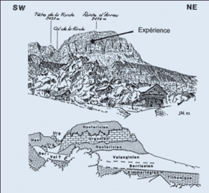
Figure 1: Sketch and geological interpretation of the Areu Towers region. View of the eastern slope of the Aravis range, from elevation 790 m (above the hamlet of Provence). Geological interpretation:“Lemanic Switzerland and Chablais” mod.
During the ascent of one of the Areu Towers in October 1986, we noted the presence of massive light limestones at the summit, exhibiting polished and striated outcrops. Given their location and altitude (2080 m), an origin attributed to the Arve glacier, which existed 15 to 20,000 years ago, was ruled out. Even considering the likelihood that these streaks would have eroded over time, the widening of the valley at this location, coupled with the diffluence of Arly toward Mégève and Isère, diminished the glacier’s thickness.
Additionally, the absence of a feeding cirque, as depicted in Figure 1, did not support the hypothesis of a local glacier. This left a tectonic origin, with students from the Geology department at the University of Geneva including [1] proposing that the effects of sliding and loading were revealed by erosion.
The walls of the Tours d’Areu consist of Barremian limestone (Urgonian facies), standing at an impressive height of 180 to 200 m. These formations oversee the steep, grassy slopes of the Hauterivien (siliceous limestone). Serving as the focal point for climbing routes, these walls are surmounted by a thin, incomplete cover from the Upper Cretaceous, exhibiting diverse facies. Moreover, in an anomalous juxtaposition (overlapping), they are once again bordered by the Hauterivian and the Barremian. The latter strata also constitute the summit of Pointe d’Areu (Figure 2 for the geological interpretation) [4].
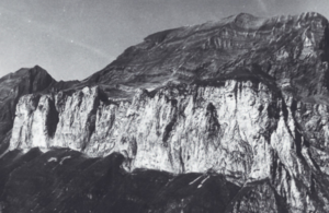
Figure 2: Aerial view of the Areu Towers wall. Top right, Pointe d’Areu (2478 m). On the left, the Col de la Forcle (2433 m)
On July 13, 1988, we securely fastened a 3 mm thick, 9 cm by 15 cm lead plate using two expansion eyebolts. The plate’s surface was intentionally left perfectly smooth. We selected a discreet location to minimize any potential interference from the infrequent rock climbers who traverse these walls.
Control visits are carried out on October 16 fromthe same year (nothing to report!), June 21, 1989, August 14, 1991 (small lines were observed), then July 6, 1994: numerous traces were then engraved in the lead. The plaque was removed on July 27, 1995. During the last three visits, we had each time noticed that gravel covered the plaque and the surrounding rocks [5].
During checks on dates when the snow was still too abundant to allow access to the experimental device (May or June), we noted the presence of blocks of snow during the descent from the steep slopes which dominated in direction of the corridors separating the towers. These bottlenecks forced the blocks to deform, to break, then to overlap. This snow, already transformed, approximately 1 to 2 m thick,had collected not only on the surface, but also torn off and then incorporated into its underside, a quantity of rock debris of varying sizes (from mm to dm). And it is during this annual crawl, during the melting period, that the objects caught in the lower layer, often transformed into ice by alternating freeze-thaws, smoothed or etched the rock surface. It is then the most angular and siliceous rock fragments which do most of this work. These elements therefore had a good time streaking our lead plate, which is softer than the Urgonian limestone (see Figure 3).
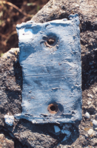
Figure 3: The lead plate as it appeared when it was removed, after 7 years on the limestone. The streaks are clearly visible. At the top right, the arrow, 1 cm long, gives the direction of snow creep.
It is crucial to exercise caution in attributing morphologies of this nature to glacial action, as a snowfield in the vicinity of a possibly vanished glacier can equally account for the phenomenon. Therefore, these striated rocks are a product of ongoing processes, unfolding right before our eyes and within our time frame, with no involvement of tectonics in this scenario.